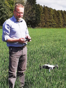
An app has been on trial at CAFRE (College of Agriculture, Food and Rural Enterprise) in Northern Ireland to gage its potential in monitoring crops in real-time. The Skippy Scout app, developed by DroneAg based in Northumberland, uses a small drone which flies autonomously to pre-selected points in a field.
How does Skippy Scout work?
As a starting point a field map image from any source is uploaded to the app. The number and location of monitoring points within the field (on that map) are then selected by the controller who simply taps on-screen to mark them. Once the drone is flying it arrives at each target point, descends to 2m above the crop using on-board sensors, and then photographs the crop in detail.
As the flight completes, the photographs upload automatically to the operator’s phone or tablet, allowing them to be reviewed immediately. The level of detail is sufficient to identify leaf damage or disease, as well as identify weeds as small as the cotyledon stage.

CAFRE crops adviser, Iain Johnston, has been trialling the app to investigate how it can reduce the time required for farmers and agronomists to effectively monitor crops. Mr Johnston said that while the use of this technology does not remove the need for boots on the ground, it does allow much greater areas to be covered in a given time. It also allows repeat visits to the same points during the season to monitor crops and the effectiveness of any previously applied treatments.
“The exciting developments with this app come as regular updates, with increasing use of Artificial Intelligence (AI) to provide information such as Green Area Index (GAI) used for Oilseed Rape fertiliser management and emergence assessment in cereals,” said Johnston.
Simple to use and fly without previous agricultural drone experience
Johnston explained the ease with which CAFRE had taken to operating Skippy Scout: “In practice the app and drone are very simple to use, even for those with no experience of drones, with all the setup of farms and fields able to be done on your phone screen. Your own field maps or yield maps can even be imported via a photograph and overlaid on Google maps to allow easier identification of areas of interest.” he said.
“Once the maps have been set up and the drone connected, a short pre-flight check to ensure everything is in order and the ‘fly now’ button appears on screen. Tapping this sees the drone take off and follow the pre-selected route, descending to take a picture before moving to the next point, all autonomously. At the end of the flight the drone will return and land itself as the pictures upload to your phone,”
Overall, CAFRE said the system looks to have great potential in monitoring crops, helping to cover more ground in the available time. The system is being continuously developed and in the future may provide further information to help link with variable rate application of inputs, helping target crop inputs more accurately to reduce the environmental impact of growing crops.


